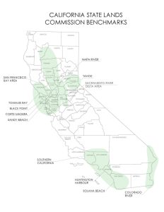
Benchmarks are used to establish uniform rental rates in specific geographic areas with large concentrations of similar facilities, mostly private recreational improvements. These benchmarks are generally updated every five years. The use of benchmarks not only improves consistency throughout that geographic region, it also improves staff efficiency in setting and adjusting rent for large numbers of leases. There are two general types of benchmarks:
- Category 1, benchmarks are applied to private docks, piers, and buoys.
- Category 2, benchmarks are applied to cantilevered decks, sundecks, or other non-water-dependent encroachments.
Category 1 Methodology
Category 1 benchmarks are based on the principle of substitution. For example, if a waterfront homeowner did not have a dock, then where would the owner dock his or her boat? The answer to this is most likely at a nearby marina.
Staff uses the following general process to establish and update a Category 1 benchmark:
- Survey nearby marinas (and buoy fields) as to docking & mooring sizes and rates;
- Slip rates usually expressed as a rental rate per linear foot;
- Extrapolate results from survey (rent per linear foot) into a rent per square foot;
- Calculate the rent due to the State using a percentage of gross income for use of tide and submerged land.
Category 2 Methodology
Category 2 benchmarks are based on nearby upland land values because the improvements (cantilevered decks, sundecks, or certain other non-water dependent encroachments) are ostensibly used as an extension of the private backyard of the upland residence – a purpose unrelated to the docking and mooring of boats.
Staff uses the following general process to establish and update a Category 2 benchmark:
- Research is conducted into recent nearby upland land values. The data is analyzed, and a per-square-foot value is determined as being representative of the area.
- The determined value may be discounted to reflect the fact that the tide and submerged land being leased may not have the same utility as the upland properties from which the data was drawn, due to topography or other physical characteristics, the nature of the use of the tide and submerged land, or certain legal constraints.
- The rental rate, also expressed on a per-square-foot basis, is then calculated.


