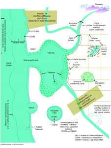
Diagram showing examples of water boundaries for different types of land including tidelands, submerged lands, tidal and non-tidal rivers, inland lakes and swamp and overflowed lands. Printable PDF
Contact
For questions about how to conduct a survey:
Jim Koepke
Lead Surveyor
916.574.2508
WaterBoundaries.Public@slc.ca.gov
One of the important responsibilities of the Commission is to determine the extent and location of California's sovereign tide and submerged lands. The California Civil Code defines the boundary of tidelands as the ordinary high water mark. (Civil Code §§ 670, 830) The Commission has exclusive jurisdiction over ungranted tide and submerged lands and is the successor agency to the Surveyor General and the Division of State Lands (Pub. Resources Code §§ 6216, 6301). The Commission is the recognized authority for determining the location of the ordinary high water mark in California. The United States Supreme Court has ruled that in tidal areas the boundary is to be located by identifying the intersection of the mean high tide line with the shore (Borax Consol., Ltd v. Los Angeles (1935) 296 U.S. 10). Typically, this includes using the National Oceanic and Atmospheric Agency's measurement and calculation of the mean high tide tidal datum in the vicinity of the lands involved. The Commission is authorized to establish the ordinary high water mark (or ordinary low water mark) by agreement or action to quiet title (Pub. Resources Code § 6357) and is a necessary party to any title or boundary action involving granted tide and submerged lands (Pub. Resources Code § 6308).
Ambulatory Water Boundary
Except for those locations where the boundary has been permanently fixed by either a court or an agreement with the Commission, the boundary of most of the lands under the Commission’s jurisdiction is what is referred to as an ambulatory boundary because it moves. This movement is because the boundary is based on the location of the water. As a practical matter, this means that surveys taken on separate days may show the boundary at different locations. It is important to realize that a watermark on a beach is not the boundary. The only way to accurately locate an ambulatory boundary is to have an area surveyed by a licensed surveyor with expertise in water boundaries. An excellent source for a comprehensive discussion of water boundaries is the three-volume “Shore and Sea Boundaries” by Aaron L. Shalowitz and Michael W. Reed. The volumes are no longer in print, however, the federal National Oceanic and Atmospheric Agency has made all three volumes available for viewing.
Offshore Boundary
The offshore boundary of the state’s sovereign lands was established in 2014 by an order entered by the United States Supreme Court in the case of United States of America, Plaintiff v. State of California, 135 S. Ct. 563; 190 L. Ed. 2d 514; 2014 U.S. LEXIS 8436 (2014). This action by the United States Supreme Court permanently fixes the offshore boundary between the United States and California, resolving a dispute that began in 1935 with the discovery of oil in Wilmington, California. There is now a fixed boundary approximately 3 nautical miles off the coast of California extending from Mexico to Oregon, providing certainty to state and federal lessors, regulators, lessees, and operators of federal and state mineral and renewable-energy leasing programs.
Tips on how to conduct a Mean High Tide Line Survey where the boundary remains ambulatory:
To determine the elevation of Mean High Tide Line on the shore one should use either the published Mean High Water elevation from a National Oceanic and Atmospheric Agency published tide station closest to the project or a linear interpolation between two adjacent tide stations, depending on the most appropriate approach in light of tidal regime characteristics.
- The current tidal datum should be used (Presently NAVD88).
- The most current tidal epoch should also be used (Presently 1983-2001 epoch).
Local published control benchmarks should be used in determining elevations at the survey site. Control benchmarks are the monuments on the ground that have been precisely located and referenced to the local tide stations and vertical datum used to calculate the Mean High Tide elevation.
- Elevation datum must match that of the tidal datum (NAVD88).
General coastal project review plan requirements can be obtained from Commission staff upon request.

